Back Charente-Maritime Afrikaans Département Charente-Maritime ALS Charente Maritimo AN شرنت مريتيم Arabic Charente Marítimu AST Dənizkənarı Şaranta Azerbaijani Прыморская Шаранта Byelorussian Прыморская Шаранта BE-X-OLD Шарант Маритим Bulgarian শারঁত-মারিতিম Bengali/Bangla
Charente-Maritime | |
|---|---|
 Prefecture building of the Charente-Maritime department, in La Rochelle | |
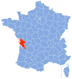
 Location of Charente-Maritime in France | |
| Coordinates: 45°57′N 0°58′W / 45.950°N 0.967°W | |
| Country | France |
| Region | Nouvelle-Aquitaine |
| Département | 4 March 1790 |
| Prefecture | La Rochelle |
| Subprefectures | Jonzac, Rochefort, Saintes, Saint-Jean-d'Angély |
| Government | |
| • President | Dominique Bussereau |
| Area | |
| • Total | 6,863.8 km2 (2,650.1 sq mi) |
| Population (2014)[3] | |
| • Total | 637,089 |
| • Density | 93/km2 (240/sq mi) |
| Demonym | Charentais maritimes |
| Time zone | UTC+1 (CET) |
| • Summer (DST) | UTC+2 (CEST) |
| ISO 3166 code | FR-17 |
| Arrondissements | 5 |
| Cantons | 27 |
| Communes | 469 |
| Website | Official website |
Charente-Maritime (Saintongeais: Chérente-Marine) is a department on the west coast of France in the Nouvelle-Aquitaine region. It is named after the Charente river, the most important river in the department, and its position along the coast.
Its prefecture is the city of La Rochelle.
- ↑ "Le Président du Département" (in French). Conseil départamental de la Charente-Maritime. Retrieved 27 May 2017.
- ↑ "Département de la Charente-Maritime (17)". Comparateur de territoire (in French). Institut national de la statistique et des études économiques - INSEE. Retrieved 27 May 2017.
- ↑ "Populations légales 2014: Recensement de la population - Régions, départements, arrondissements, cantons et communes" (in French). Institut national de la statistique et des études économiques - INSEE. Retrieved 27 May 2017.

