Back Xeografía d'Haití AST Geography of Haiti English Geografía de Haití Spanish جغرافیای هائیتی Persian Haitin maantiede Finnish Géographie d'Haïti French Jewografi Ayiti HT Haitisk geografi NN Haitis geografi NB Geografia Haiti Polish
| Geography of Haiti | |

| |
| Continent | Americas |
| Region | Caribbean |
| Coordinates | 19°00' N 72°25' W |
| Area | Ranked 147 27,750 km² |
| Coastline | 1,771 km |
| Borders | 360 km |
| Highest point | Pic la Selle 2,680 m |
| Lowest point | Caribbean Sea 0 m |
| Longest river | Artibonite |
| Largest lake | Étang Saumâtre |
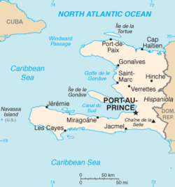
Haiti (French: Haïti; Haitian Creole: Ayiti) is a country in the Caribbean.[1] It occupies the western three-eighths of Hispaniola;[2][3] the Dominican Republic occupies the eastern five-eighths (63%) of the island.
The country has a total area of 27,750 km2 (10,710 sq mi), of which 27,560 km² is land and 190 km² is water. Haiti has 1,771 km (1,100 mi) of coast-line and a 360 km (220 mi) border with the Dominican Republic.[4]
The limits of the country are the Dominican Republic to the east, the Atlantic Ocean to the north, and the Caribbean Sea to the south and west. The capital, Port-au-Prince, is a seaport located on the west coast.
Cuba is to the northwest and Jamaica to the southwest of Haiti; the Winward Passage separates Cuba from Haiti (and Hispaniola), and the Jamaica Channel separates Haiti from Jamaica.
There are two large peninsulas: the Northwestern on the Atlantic Ocean, and the Southern peninsulas on the Caribbean Sea. The Northwestern, or just Northern, Peninsula (French: Presqu'île du Nord-Ouest) is also known as the Saint-Nicolas Peninsula; it was the first part of the Hispaniola visited by Christopher Columbus on 1492. The historical name of the Southern Peninsula (French: Presqu'île du Sud) was Tiburón Peninsula.[5]
Between those two large peninsulas there is a gulf (a very large bay): the Gulf of Gonâve. It is named so after the Gonâve Island that is in the middle of the gulf. It was called also Gulf of Léogane after the city of Léogane, one of the oldest in Haiti.[4]
- ↑ "History Archives".
- ↑ Dardik, Alan, ed. (2016). Vascular Surgery: A Global Perspective. Springer. p. 341. ISBN 978-3-3193-3745-6. Retrieved 8 May 2017.
- ↑ Josh, Jagran, ed. (2016). "Current Affairs November 2016 eBook". p. 93. Retrieved 8 May 2017.
- ↑ 4.0 4.1 "Geography,Government,Haiti,History". InfoPlease.
- ↑ "Geography". ThoughtCo.