Back Indre (département) Afrikaans Département Indre ALS Indre AN أندر (إقليم فرنسي) Arabic Endr Azerbaijani Département Indre BAR Эндр (дэпартамент) Byelorussian Эндр (дэпартамэнт) BE-X-OLD Ендър (департамент) Bulgarian Indre (departamant) Breton
Indre | |
|---|---|
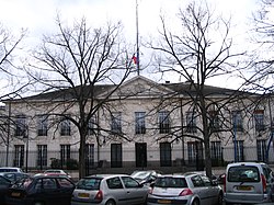
 Prefecture building of the Indre department, in Châteauroux | |
 Location of Indre in France | |
| Coordinates: 46°46′N 1°36′E / 46.767°N 1.600°E | |
| Country | France |
| Region | Centre-Val de Loire |
| Département | 4 March 1790 |
| Prefecture | Châteauroux |
| Subprefectures | Le Blanc, La Châtre, Issoudun |
| Government | |
| • President | Serge Descout |
| Area | |
| • Total | 6,790.6 km2 (2,621.9 sq mi) |
| Population (2014)[3] | |
| • Total | 226,175 |
| • Density | 33/km2 (86/sq mi) |
| Demonym | Indriens |
| Time zone | UTC+1 (CET) |
| • Summer (DST) | UTC+2 (CEST) |
| ISO 3166 code | FR-36 |
| Arrondissements | 4 |
| Cantons | 13 |
| Communes | 243 |
| Website | Official website |
Indre is a department in the centre of France in the Centre-Val de Loire region. It is named after the Indre river, the most important river in the department.
Its prefecture is Châteauroux.
- ↑ "Institution" (in French). Conseil Départemental de l'Indre. Retrieved 25 July 2017.[permanent dead link]
- ↑ "Département de L'Indre (36) - Résumé statistique". Publications et statistiques pour la France ou les régions (in French). Institut national de la statistique et des études économiques - INSEE. Retrieved 11 September 2016.
- ↑ "Populations légales 2014 des départements et des collectivités d'outre-mer" (in French). Institut national de la statistique et des études économiques - INSEE. Retrieved 25 July 2017.

