Back Johor Bahru Afrikaans جوهر بهرو Arabic Johor Bahru AST Cohor Baru Azerbaijani جوهور باهرو AZB Джахор-Бару Byelorussian Джохор Бахру Bulgarian Juhur Bahru, Malaysia BJN জোহর বাহরু Bengali/Bangla Johor Bahru Catalan
Johor Bahru | |
|---|---|
| Bandaraya Johor Bahru | |
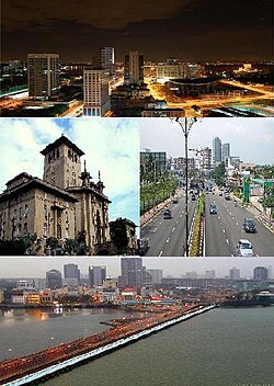
 Clockwise from top left: Night view of Johor Bahru, Sultan Ibrahim Building, Tebrau Highway & Johor–Singapore Causeway | |
| Nickname(s): JB, Bandaraya Selatan (Southern City) | |
| Motto(s): Berkhidmat, Berbudaya, Berwawasan (English: "Servicing, Cultured, Visionary") | |
Location of Johor Bahru in Peninsular Malaysia | |
| Coordinates: 1°29′00″N 103°44′00″E / 1.48333°N 103.73333°E | |
| Country | |
| State | |
| Administrative Areas | List |
| Establishment | 10 March 1855 (as Tanjung Puteri) |
| Granted city status | 1 January 1994 |
| Founded by | Temenggong Daeng Ibrahim |
| Government | |
| • Mayor | Amran bin A. Rahman |
| • Council | Johor Bahru City Council |
| • Council Members | List |
| Area | |
| • Total | 185 km2 (71 sq mi) |
| Elevation | 36.88 m (121.00 ft) |
| Population (2010) | |
| • Total | 1,334,188[1] |
| • Density | 7,409/km2 (19,190/sq mi) |
| Time zone | UTC+8 (MST) |
| • Summer (DST) | Not observed |
| Website | mbjb.gov.my |
Johor Bahru (also spelled Johor Baharu, Johor Baru,[nb 1] or Johore Bahru; shortly as JB) is the capital city of Johor, Malaysia.[2] Pasir Pelangi, the royal village, is located in Johor Bahru.
The city in itself has a population of 1,334,188[1] as of 2010. The metropolitan area of Johor Bahru, also known as Iskandar Malaysia, has a population of 1,730,000.[3]
- ↑ 1.0 1.1 "Population in the State of Johor" (PDF). Department of Statistics Malaysia. Archived from the original (PDF) on 2012-02-27. Retrieved 2013-04-17.
- ↑ "Hotels in Johore Bahru". Asia Rooms.com. Archived from the original on 2006-06-29. Retrieved 2006-06-24.
- ↑ "Shopping haven in Iskandar Malaysia". The Star. Retrieved 2013-04-17.
<ref group=nb> tags on this page, but the references will not show without a {{reflist|group=nb}} template (see the help page).
