Back Navassa Afrikaans Navassa ALS Nafāssa-Īeg ANG جزيرة نافاسا Arabic جزيره نافاسا ARZ Navassa adası Azerbaijani Navassa BAR Наваса Byelorussian Наваса BE-X-OLD Наваса Bulgarian
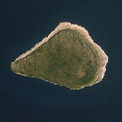
Navassa Island
Navaza | |
|---|---|
 Image of Navassa Island | |
| Coordinates: 18°24′10″N 75°0′45″W / 18.40278°N 75.01250°W | |
| Country | United States / Haiti |
| Status | Unorganized, unincorporated territory |
| Claimed by the United States & Haiti | September 19, 1857 |
| Government | |
| • Body | Caribbean Islands National Wildlife Refuge Complex (under authority of the U.S. Fish and Wildlife Service) |
| • Project Leader | Susan Silander |
| Area | |
| • Total | 2.1 sq mi (5.4 km2) |
| • Water | 0 sq mi (0 km2) |
| Highest elevation | 85 ft (26 m) |
| Lowest elevation | 0 ft (0 m) |
| Population | |
| • | 0 |
| Time zone | UTC-5 (Eastern Time Zone) |
| APO / Zip Code | 96898 |
| Administered by | United States |
| Claimed by | Haiti |
Navassa Island, or La Navase in Haitian Creole, is a small island without anyone living on it in the Caribbean Sea.[1] It is located ninety miles south of Guantanamo Bay, Cuba. The United States government claims the two-square-mile island as a territory of the United States, and it is under control of the U.S. Fish and Wildlife Service. The island is also claimed by Haiti.
Some sailors sailing with Christopher Columbus named Navassa in 1504, because no fresh water could be found there.
A captain named Peter Duncan gave it to the U.S. in the late 1850s, for the purpose of guano mining. After a rebellion in 1889, and the Spanish-American War of 1898, the mining was put to an end.
With the opening of the Panama Canal in 1914, Navassa became important again, because of a lighthouse being built there. After World War II, no one lived on it again.
In 1996, Navassa's light was put out of use, and the island was transferred to the U.S. Department of the Interior. Three years later in 1999, the Fish and Wildlife Service received ownership of the island.
- ↑ "Navassa Island" at CIA World Factbook Archived 2015-09-05 at the Wayback Machine; retrieved 2013-4-19.
