Back Nineve Afrikaans Ninive ALS ነነዌ Amharic نينوى Arabic ܢܝܢܘܐ (ܡܕܝܢܬܐ) ARC نينوى ARZ Nínive AST Nineviya Azerbaijani Ниневия Bashkir Ніневія Byelorussian
Nineveh | |
|---|---|
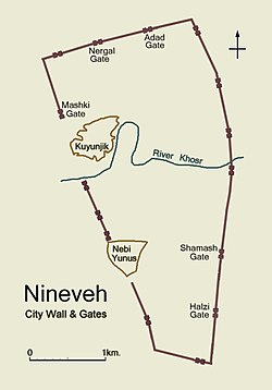
 Simplified plan of ancient Nineveh showing city wall and location of gateways | |
| Coordinates: 36°21′34″N 43°09′10″E / 36.35944°N 43.15278°E |

Nineveh was an ancient Assyrian city on the eastern side of the Tigris River. It was the capital and a major city of the Assyrian empire.[1] Its ruins are across the river from the modern-day city of Mosul, Iraq.[2]
The ruins of Nineveh are surrounded by the remains of a massive stone and mudbrick wall dating from about 700 BC. The wall was bout 12 km in length. The stone retaining wall had projecting stone towers spaced about every 18 metres (59 ft). The stone wall and towers were topped by three-step parapets.
The city wall had fifteen monumental gateways. They were checkpoints for people entering and exiting the city. They probably had barracks and armouries. With the inner and outer doors shut, the gateways were fortresses. The gateways had passages and interior chambers lined with finely cut stone. A stairway led from one of the interior chambers to the top of the mudbrick wall.
The city wall was destroyed by ISIS by February, 2015. The wall was destroyed during an effort to destroy historical buildings and monuments in the province by the jihadist rebel group.[3]
- ↑ 2 Kings 19:36
- ↑ Menko Vlaardingerbroek 2004. The founding of Nineveh and Babylon in Greek historiography. Iraq, vol. 66, Nineveh. Papers of the 49th Rencontre Assriologique Internationale, Part One, pp. 233-241.
- ↑ "ISIS has blown up the historic wall of Nineveh". Archived from the original on January 20, 2019. Retrieved March 2, 2015.
