Back Sint-Laurensrivier Afrikaans Sankt-Lorenz-Strom ALS Río Sant Lorient AN Sanctes Laurentes Ēa ANG نهر سانت لورانس Arabic نهر سانت لورانس ARZ Ríu San Llorienzo AST Micta sipi ATJ Müqəddəs Lavrentiya çayı Azerbaijani سنلوران چایی AZB
| Saint Lawrence River Fleuve Saint-Laurent, Fleuve St-Laurent, St-Lawrence River, St-Laurent River | |
|---|---|
 Saint Lawrence River near Alexandria Bay | |
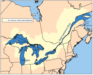
 Map of the Saint Lawrence/Great Lakes Watershed | |
| Etymology | Saint Lawrence of Rome |
| Location | |
| Country | Canada, United States |
| Provinces | Ontario, Quebec |
| State | New York |
| Major City | Montreal |
| Metropolitan Area | Greater Montreal |
| Physical characteristics | |
| Source | Lake Ontario |
| - location | Kingston, Ontario / Cape Vincent, New York |
| - coordinates | 44°06′N 76°24′W / 44.100°N 76.400°W |
| - elevation | 74.7 m (245 ft) |
| Mouth | Gulf of St. Lawrence / Atlantic Ocean |
| - location | Quebec, Canada |
| - coordinates | 49°30′N 64°30′W / 49.500°N 64.500°W |
| - elevation | 0 m (0 ft) |
| Length | 500 km (310 mi)Excluding the estuary. Ca. 1200 km if included. |
| Basin size | 1,344,200 km2 (519,000 sq mi)[1] |
| Discharge | |
| - location | below the Saguenay River |
| - average | 16,800 m3/s (590,000 cu ft/s) |
The Saint Lawrence River (French: fleuve Saint-Laurent; Tuscarora: Kahnawáʼkye;[2] Mohawk: Kaniatarowanenneh, meaning "big waterway") is a big river in eastern North America. It flows between the Canadian province of Quebec & Ontario and the American state of New York, and through the major Canadian city of Montreal. It is the third largest river in Canada.
The river drains water from the Great Lakes into the Atlantic Ocean. It is more than three thousand kilometres long. The river meets the Atlantic Ocean in a big "estuary" or bay, the biggest in the world; this is called the Gulf of Saint Lawrence.
The Canadian cities of Kingston, Montreal, Trois-Rivières and Quebec City are on this river. The Saint Lawrence Seaway allows ships to go up the river and through the Great Lakes right into the middle of North America.
- ↑ Natural Resources Canada, Atlas of Canada - Rivers Archived 2012-03-29 at the Wayback Machine
- ↑ Rudes, B. Tuscarora English Dictionary Toronto: University of Toronto Press, 1999