Back Lhasa ACE Lhasa Afrikaans ላሳ Amharic Lhasa AN لاسا Arabic Lhasa AST Lhasa Azerbaijani Лхаса Bashkir Лхаса Byelorussian Лхаса BE-X-OLD
Lhasa
拉萨市 ལྷ་ས་གྲོང་ཁྱེར། | |
|---|---|
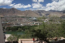
 View of Lhasa from Potala Palace | |
 | |
 Location of Lhasa prefecture-level city jurisdiction in the Tibet Autonomous Region | |
| Coordinates (Lhasa prefectural government): 29°39′12″N 91°10′19″E / 29.6534°N 91.1719°E | |
| Country | China |
| Autonomous region | Tibet |
| Municipal seat | Chengguan District |
| Government | |
| • Type | Prefecture-level city |
| • Body | Lhasa Municipal People's Congress |
| • CCP Secretary | Purpu Tonchup |
| • Congress Chairman | Dawa |
| • Mayor | Go Khok |
| • CPPCC Chairman | Yuan Xunwang |
| Area | |
| • Prefecture-level city | 29,274 km2 (11,303 sq mi) |
| • Urban | 53 km2 (20 sq mi) |
| Elevation | 4,150 m (13,620 ft) |
| Population (2020 Census)[1] | |
| • Prefecture-level city | 867,900 |
| • Density | 30/km2 (77/sq mi) |
| GDP[2] | |
| • Total | CN¥ 74.2 billion US$ 11.5 billion |
| • Per capita | CN¥ 85,000 US$ 13,100 |
| Time zone | UTC+8 (China Standard) |
| Area code | 891 |
| ISO 3166 code | CN-XZ-01 |
| Licence plate prefixes | 藏A |
| Website | www |
| Lhasa | |||||||||||||||
|---|---|---|---|---|---|---|---|---|---|---|---|---|---|---|---|
 "Lhasa" in Simplified Chinese characters (top), Traditional Chinese characters (middle), and Tibetan script (bottom) | |||||||||||||||
| Chinese name | |||||||||||||||
| Simplified Chinese | 拉萨 | ||||||||||||||
| Traditional Chinese | 拉薩 | ||||||||||||||
| Hanyu Pinyin | Lāsà | ||||||||||||||
| Literal meaning | (Tibetan) "Place of the Gods" | ||||||||||||||
| |||||||||||||||
| Also known as | |||||||||||||||
| Simplified Chinese | 逻些 | ||||||||||||||
| Traditional Chinese | 邏些 | ||||||||||||||
| Hanyu Pinyin | Luóxiē | ||||||||||||||
| |||||||||||||||
| Tibetan name | |||||||||||||||
| Tibetan | ལྷ་ས་ | ||||||||||||||
| |||||||||||||||
Lhasa[a] is a prefecture-level city,[b] one of the main administrative divisions of the Tibet Autonomous Region of China. It covers an area of 29,274 square kilometres (11,303 sq mi) of rugged and sparsely populated terrain. Its urban center is Lhasa, with around 300,000 residents, which mostly corresponds with the administrative Chengguan District, while its suburbs extend into Doilungdêqên District and Dagzê District. The consolidated prefecture-level city contains additional five, mostly rural, counties.
The city boundaries roughly correspond to the basin of the Lhasa River, a major tributary of the Yarlung Tsangpo River. It lies on the Lhasa terrane, the last unit of crust to accrete to the Eurasian plate before the continent of India collided with Asia about 50 million years ago and pushed up the Himalayas. The terrain is high, contains a complex pattern of faults and is tectonically active. The temperature is generally warm in summer and rises above freezing on sunny days in winter. Most of the rain falls in summer. The upland areas and northern grasslands are used for grazing yaks, sheep and goats, while the river valleys support agriculture with crops such as barley, wheat and vegetables. Wildlife is not abundant, but includes the rare snow leopard and black-necked crane. Mining has caused some environmental problems.
The 2000 census gave a total population of 474,490, of whom 387,124 were ethnic Tibetans. The Han Chinese population at the time was mainly concentrated in urban areas. The prefecture-level city is traversed by two major highways and by the Qinghai–Tibet railway, which terminates in the city of Lhasa. In the future, the Sichuan–Tibet railway currently under construction will expect to start operations in 2030.[5] Two large dams on the Lhasa River deliver hydroelectric power, as do many smaller dams and the Yangbajain Geothermal Field. The population is well-served by primary schools and basic medical facilities, although more advanced facilities are lacking. Tibetan Buddhism and monastic life have been dominant aspects of the local culture since the 7th century. Most of the monasteries were destroyed during the Cultural Revolution, but since then many have been restored and serve as tourist attractions.
- ^ 拉萨人口. Archived from the original on 2019-07-01. Retrieved 2017-07-27.
- ^ "拉萨市2019年国民经济和社会发展统计公报" (in Chinese). 12 March 2021. Retrieved 12 March 2021.
- ^ "Lhasa". Lexico UK English Dictionary. Oxford University Press. Archived from the original on May 18, 2021.
- ^ Barnett 1996, p. 82.
- ^ "Tibet railway among new lines to open in China". international rail journal. 28 June 2021.
Cite error: There are <ref group=lower-alpha> tags or {{efn}} templates on this page, but the references will not show without a {{reflist|group=lower-alpha}} template or {{notelist}} template (see the help page).