Back Shikoku ACE Sjikokoe Afrikaans شيكوكو Arabic شيكوكو ARZ Rexón de Shikoku AST Şikoku Azerbaijani شیکوکو AZB Сикоку Bashkir Shikoku BAN Šėkoku BAT-SMG
This article has multiple issues. Please help improve it or discuss these issues on the talk page. (Learn how and when to remove these messages)
|
Native name: 四国 | |
|---|---|
 The island of Shikoku, Japan | |
 | |
| Geography | |
| Location | Japan |
| Archipelago | Japanese archipelago |
| Area | 18,801.73 km2 (7,259.39 sq mi) |
| Area rank | 50th |
| Length | 225 km (139.8 mi) |
| Width | 50–150 km (31–93 mi) |
| Highest elevation | 1,982 m (6503 ft) |
| Highest point | Mount Ishizuchi |
| Administration | |
| Prefectures | |
| Largest settlement | (as of 1 May 2022)) |
| Demographics | |
| Population | 3,630,320 (1 May 2022) |
| Pop. density | 193/km2 (500/sq mi) |
| Ethnic groups | Japanese |
| Additional information | |
| Time zone | |
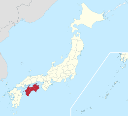
Shikoku (四国, Shikoku, lit. 'four provinces'), Japanese pronunciation: [ɕikokɯ] is the smallest of the four main islands of Japan. It is 225 km or 139.8 mi long and between 50 and 150 km or 31.1 and 93.2 mi at its widest. It has a population of 3.8 million, the least populated of Japan's four main islands. It is south of Honshu and northeast of Kyushu.[1] Shikoku's ancient names include Iyo-no-futana-shima (伊予之二名島), Iyo-shima (伊予島), and Futana-shima (二名島), and its current name refers to the four former provinces that make up the island: Awa, Tosa, Sanuki, and Iyo.[2]
- ^ Boquet, Yves (2017). The Philippine Archipelago. Springer. p. 16. ISBN 9783319519265.
- ^ "Shikoku and Awaji Island" (PDF). Japan National Tourism Organization. September 2011. Archived (PDF) from the original on 2013-02-04. Retrieved 2013-05-02.